LE MEDITERRANEE CAMPSITE ACCESS PLAN
Access by car to Le Méditerranée campsite is very simple. Just take the Béziers-West motorway exit and head for Valras - Beach.
Coordinates to enter your GPS browser Latitude - Longitude 43.2359 ( 43-14’) - 3.2685 (3-16’)
Address 1: Route de Vendres - 34350 - Valras - Plage
Address 2: Fishermen’s Road - 34350 - Valras - Plage
Le Méditerranée - Valras - Plage
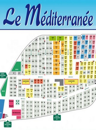
You have the ability to zoom in and move around this map. Simply press and hold the left button of the mouse and move.
Map of Le Méditerranée campsite
To get to Le Méditerranée campsite, if you arrive by car, you will have to take the Béziers-Ouest motorway exit. There are two motorway exits in Béziers. Béziers-est and Béziers-Ouest. Access to Valras - Beach is of course possible from Béziers-est, but in the middle of summer you may find yourself facing major traffic problems. The right solution to avoid traffic is to take Béziers West and immediately towards Vendres - Valras. At the entrance to Valras you will only have 500 meters to go to find the campsite. Take the valras center direction and as soon as you arrive in front of the Family Park, the inflatable structures, the entrance to the campsite is right opposite.
If you arrive at the Gare de Béziers, take the E line bus that takes you to Valras. The bus stop is called "Portes de Valras" and is located on the sidewalk of the campsite.
Non-contractual photos and videos